


Fifty million years ago, volcanoes erupted in several areas of central Montana. The upwelling of magma which fed these volcanoes was largely responsible for the Bears Paw Uplift and for several other isolated mountain ranges and laccoliths that eroded to form large buttes in central Montana. Laccoliths are a type of intrusive igneous formation also called “plutonic formations” or “igneous intrusions.” This means that they were formed as magma cooled beneath the surface.
With laccoliths the magma moves into an area beneath the ground, causing the overlying rock layers to dome upward. Eventually the magma hardened, creating a network of dikes and laccoliths beneath the surface.
Erosion has worn away the overlying sedimentary rock, leaving remnants of the more resistant igneous formations. Although layers are usually associated with sedimentary rock, the igneous rock of the buttes is made up of very distinct layers. Closer examination reveals thin lighter-colored layers between each of the thicker, darker layers. This may have happened as a result of differences in the densities and/or freezing points of various minerals in the magma. Another theory is that the thin light-colored layers formed as a result of water soaking in from the sandstone above before the next layer of magma was injected.
The most prominent of these Laccoliths offering endless scenery, hiking, wildlife viewing, and extraordinary sunrises and sunsets are:
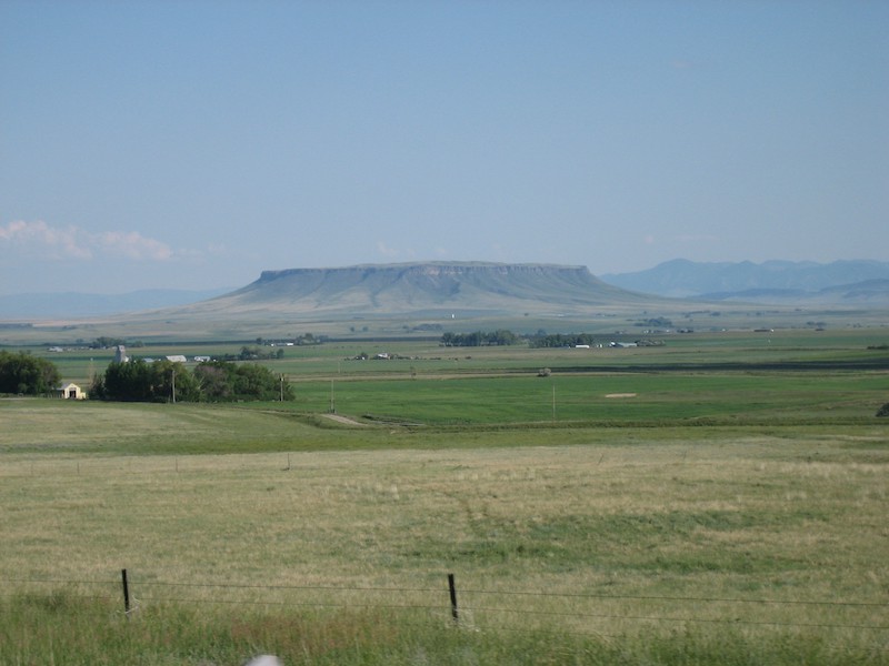
Square Butte and Round Butte
-fifty miles west of GreatFalls between Stanford and Geraldine. These laccoliths at the eastern edge of the Highwood Mountains are part of the Central Montana Alkalic Province. They contain a variety of rock types, including shonkinite, syenite, and pegmatite. This Square Butte has been designated an Outstanding Natural Area. The flat topped butte juts 2,400 feet above the surrounding plains. With its soaring buttresses, spires, and pinnacles it is a compelling and imposing site. Scenic Square Butte has exceptional wildlife values with a herd of about eighty mountain goats that can be seen consistently on top. The butte’s steep cliffs provide outstanding nesting habitat for raptors.
Four buttes (Crown Butte, Shaw Butte, Cascade Butte and Square Butte also known as Charlie’s Butte)
-located 15-25 miles west of Great Falls. The mile-wide tableland of rock on Charlie’s Butte was used as a backdrop in numerous C.M. Russell paintings. Nature Conservancy bought the Crown Butte in 1982 in order to preserve the natural grassland ecosystem located on top of the butte. Except for an occasional hiker, the ecosystem sits undisturbed about 900 feet above the surrounding northern great plains. The dikes from the four buttes can be seen converging near the town of Cascade, twenty miles southeast of Crown Butte.
Box Elder Butte south of Havre, Centennial Mountain northeast of Big Sandy and Snake Butte south of Harlem in the Bears Paw Mountains. The Mountains cover about forty miles east to west and about twenty miles in distance from north to south, within the boundaries of Hill County, Blaine County and the Rocky Boys Indian Reservation.
Square Butte west of Great Falls captured the attention of Meriwether Lewis as he passed through the White Cliffs of the Missouri. Later from his portage camp at the upper end of the Falls of the Missouri in 1805 he wrote:
This mountain has a singular appearance. It is situated in a level plain, it’s sides stand nearly at right angles with each other and are each about a mile in extent. These are formed of a yellow clay only without the mixture of rock or stone of any size and rise perpendicularly to the height of 300 feet. The top appears to be a level plain and from the eminence on which I was yesterday I could see that it was covered with a similar cost of grass with the plain on which it stands. The surface appears also to possess a tolerable fertile mold of 2 feet thick, and is to all appearance inaccessible. From it’s figure we gave it the name of fort mountain.
His observations weren’t precisely correct considering the fact that he was thirteen miles away from it (not ten, as he had estimated). The Butte is also made of stone, not clay and his comparison of the grass on top with that on the adjacent prairie would probably have been correct, but it was irrelevant. Owing to the earth’s curvature, from thirteen miles away he could see only the upper 970 feet or so; the lower 130 feet
of the outslope, as well as the prairie at its base, were hidden beyond his horizon.